210717 | No part of Cornwall now Covid cluster free amid large spikes in some areas
Submitted by InYourArea and ... on Tue, 20/07/2021 - 11:06.
17th July
No part of Cornwall now Covid cluster free amid large spikes in some areas
No part of Cornwall now Covid cluster free amid large spikes in some areas
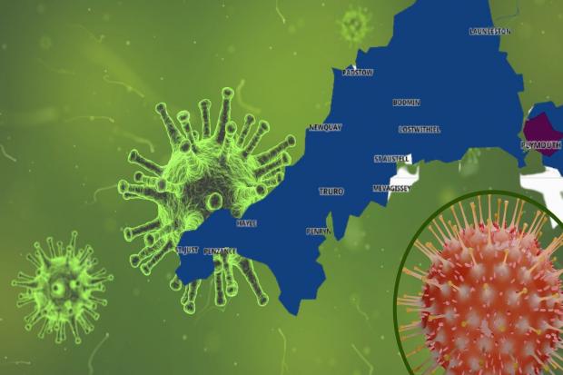
Every part of Cornwall now has at least three new cases of Covid-19 after figures rose over the latest seven-day period.
West Cornwall has seen some big rises this week, including Penzance where cases across the town as a whole have gone from 34 to to 74 in seven days. It is is made up of three cluster areas: Penzance North (34 cases, up 20), Penzance South & Newlyn (12, up four) and Penzance Quay (28, up ten).
Not far away, Hayle has seen cases rise from 11 to 38 in the same time period.
Falmouth is another area that has started to see cases rise again, although not at the same rate as after the G7 and half term. Figures in its three cluster areas are now: Falmouth West & South (38, up five), Falmouth East (31, up ten) and Falmouth North (37, up 12).
Some of the highest case figures can be found in Newquay and the surrounding area though. The town has a combined 127 cases (Newquay West 54, up 22 and Newquay East 73, up 35), while St Columb Minor & Porth has 46 cases (up nine) and St Columb Major & St Mawgan 38 (up 15).

Further up the Duchy, Wadebridge has seen cases rise from eight to 32.
All figures relate to new cases recorded across the seven days leading up July 12, the most recent data given, with the most recent five days not shown due to being incomplete.
It's as Cornwall and Isles of Scilly recorded a total of 1,320 cases during the same time period - 325 more than the previous week, marking a rise of 32.7%.
The case rate is now averaging 230.8 cases per 100,000 people, compared to 174.4 cases per 100,000 people last Saturday.
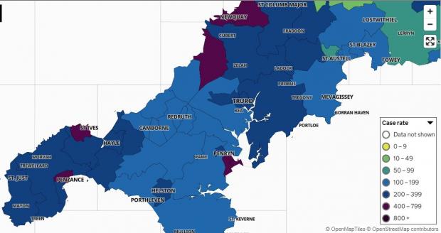
It means that the map of Cornwall has gone from mid blue to dark blue in the case rate colour scheme - just two down from the highest level.

The map shows positive cases by 'Middle Super Output Area' - the name the government gives to the break-up of larger towns and groups of neighbouring towns and villages, with groupings covering a greater area than others.
The minimum population in each area is 5,000 and the average is 7,200.
Clusters are only shown when there are three or more new cases reported at any one time.
Anywhere with between zero and two cases shows white in order to "protect the privacy of individuals and prevent disclosure", the accompanying information states.
READ NEXT:
The full list of clusters now on the map is:
St Just & Land's End 12
West Penwith & St Buryan 20
Penzance South & Newlyn 12
Penzance North 34
Penzance Quay 28
Towednack, Lelant & Carbis Bay 14
St Ives & Halsetown 28
Hayle 38
Marazion, St Erth & Gwinear Gwithian 20
Porthleven, Breage & Praa Sands 12
Helston 36
The Lizard 10
Ponsanooth, Mabe Burnthouse & Constantine 19
Falmouth West & South 38
Falmouth East 31
Falmouth North 37
Penryn 25
Crowan, Wendron & Stithians 13
Camborne West 10
Camborne South 9
Camborne East 15
Pool & Illogan Highway 13
Illogan & Portreath 13
Redruth North 13
Redruth South 11
St Day & Lanner 10
Mylor Bridge & Frogpool 9
Shortlanesend, Chacewater & Carnon Downs 15
Truro West 28
Truro South & Central 16
Truro East 18
St Agnes & Mount Hawke 15
Perranporth & Goonhavern 24
Grampound Road, St Newlyn East and Cubert 20
Probus & Roseland 21
Mevagissey & Polgooth 9
Trewoon, Coombe & Foxhole 20
Newquay West 54
Newquay East 73
St Columb Minor & Porth 46
St Columb Major & St Mawgan 38
Roche & Goss Moor 27
St Austell North & Carclaze 7
St Austell Central 17
St Austell East & Carlyon Bay 13
Par 11
Tywardreath & Fowey 9
Lanreath, Pelynt & Polraun 5
Lostwithiel & Penwithick 13
Bodmin West 5
Bodmin East 18
St Breward, Tredethy & Lanivet 3
Trebetherick & Whitecross 9
Wadebridge 32
Padstow & St Issey 21
Dobwalls, Addington & Menheniot 25
Liskeard 8
St Germans & St Mellion 7
Kingsand, Antony & Maryfield 25
Torpoint 17
Mid Saltash 16
Saltash Town & Pillmere 18
Saltash Latchbrook & St Stephens 12
Callington & Pensilva 7
Gunnislake & Calstock 4
St Neot & St Cleer 7
Altarnun & Stoke Climsland 14
Launceston 13
Camelford & Tresmeer 6
Crackington & Tintagel 7
Poundstock & Kilkhampton 5
Bude & Stratton 6
Looe & Polperro 6
- Printer-friendly version
- Login or register to post comments
- Permalink
Contributions
- Angarrack Defibrillator Team (25)
- Angarrack Inn (336)
- Angarrack Methodist Chapel (3)
- Carol (15)
- Gail (1)
- GordonG (12)
- Hayle Development Group on Facebook (5)
- Hayle Harbour Authority (4)
- Hayle Town Council (5)
- louise (1)
- Lynne (94)
- Mal (1)
- Neil (22)
- Neils Garden Care (9)
- Russell (21)
- Secretary - Christmas Lights (118)
- Steve (3)
- webmaster (5023)
Book page
Similar
- 210715 | Covid in Cornwall: Thursday, July 15 - a big jump in cases
- 210715 | As Covid cases continue to rise just one area of Cornwall remains off the cluster map
- 210716 | The government still “expect” and “recommend” people to wear a face covering in crowded and enclosed spaces
- 210715 | Crantock bar to keep Covid safety measures after restrictions lift
- 210401 | Old Cornwall Society Memorial Plaque | Hayle Pump 155 April/May 2021
Similar across site
- 210327 | No part of Cornwall now Covid cluster free amid large spikes in some areas
- 210715 | Covid in Cornwall: Thursday, July 15 - a big jump in cases
- 210715 | As Covid cases continue to rise just one area of Cornwall remains off the cluster map
- 210716 | The government still “expect” and “recommend” people to wear a face covering in crowded and enclosed spaces
- 210715 | Crantock bar to keep Covid safety measures after restrictions lift


Recent comments
1 week 45 min ago
36 weeks 4 days ago
38 weeks 2 days ago
38 weeks 2 days ago
48 weeks 4 hours ago
1 year 8 weeks ago
1 year 33 weeks ago
1 year 43 weeks ago
2 years 2 weeks ago
3 years 27 weeks ago