
Articles
190908 | White storks spread across England for first time in 600 years as rewilding project tackles biodiversity crisis
Submitted by via Google News... on Thu, 12/09/2019 - 00:00.
White storks spread across England for first time in 600 years as rewilding project tackles biodiversity crisis
Sixth mass-extinction event to ever face our planet is currently underway, scientists warn read more »
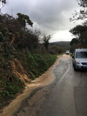
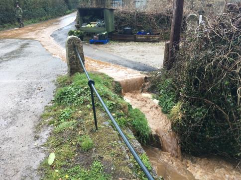
The Angarrack Stream | Flood Profile for Hayle version 7, April 2018
Submitted by Angarrack.info ... on Sat, 01/06/2019 - 00:00.
The Angarrack Stream
The Angarrack Stream flows into Copperhouse Pool and is tidal to Phillack. Flood risks are significant in the area around Marsh Lane and Loggans Mill roundabout, where the A30 is particularly vulnerable, and along the built up area between the roundabout and Copperhouse Pool. At times of high flow in the Angarrack Stream the Environment Agency pumps water from the pumping station upstream of Marsh Lane to further downstreamon the Angarrack River. read more »
Angarrack Flood Plan 2018
Submitted by via Hayle Town ... on Thu, 06/12/2018 - 12:46.

 Flood Map - Angarrack Flood Plan 2018")


Note OCR used - please check original https://www.hayletowncouncil.net/wp-content/uploads/2018/04/Angarrack-fl... read more »
1981 | The new Lelant to Hayle Ferry cuts across the estuary | BFI
Submitted by via BFI on Mon, 15/10/2018 - 11:07.

181001 | Copperhouse gate refurbishment
Submitted by via Hayle Pump on Tue, 09/10/2018 - 14:02.
Copperhouse gate refurbishment will ensure Hayle continues to be protected from flooding
This autumn the Environment Agency will carry out refurbishment work on the Copperhouse Gate.
The gate is a critical part of the Angarrack Flood Alleviation Scheme which provides flood protection to 138 properties in the Copperhouse area of Hayle. The refurbishment will ensure that the existing level of flood defence is maintained for a further 30 years.
Work will be carried out by Environment Agency contractors BMMJV and will begin this November. Refurbishment of the gate will take approximately 7 weeks and during this time an area of the North Quay will not be accessible to the public. read more »
1825 | Hayle Causeway opens
Submitted by Angarrack.info ... on Tue, 01/05/2018 - 00:00.
"A work most beneficial to the whole country was com- pleted at Hayle in the year 1825, under the authority of an Act of Parliament. The passage across the main estuary was frequently dangerous and always interrupted by the tide ; several of the branches could not be passed at high water, and lives were not unfrequently lost. A causewayread more »
180313 | Currently investigating the sources of #nutrients in the #hayle estuary. Continuous #monitoring in the #Freshwater catc
Submitted by via Twitter on Tue, 13/03/2018 - 01:00.
Currently investigating the sources of #nutrients in the #hayle estuary. read more »
160601 | Hayle residents mark 100 years since the Battle of the Somme | The Cornishman
Submitted by Angarrack.info ... on Mon, 15/02/2016 - 01:00.
Via http://www.cornishman.co.uk/Victims-flooding-Hayle-appeal-Environmental/...
Victims of flooding in Hayle appeal for Environmental Agency to take action over river
| Posted: February 16, 2016 read more »
Angarrack Gauge Levels 2014 to date...
Submitted by Angarrack.info ... on Thu, 03/12/2015 - 14:21.


There is an online gauge http://www.gaugemap.co.uk/#!Detail/8207/3553 see also Angarrack Screen Webcam these graphs show the level in previous years.
Angarrack Flood Plan 2015
Submitted by Angarrack.info ... on Tue, 22/09/2015 - 12:37.

 Flood Map - Angarrack Flood Plan 2015")


Note OCR used - please check original http://hayletowncouncil.net/documents/angarrackfloodplan2915.pdf read more »

