210802 | Covid-19 continues to soar in Newquay with infection rates still double the national average, the latest figures show
Data show mixed picture in Cornwall's Covid capital
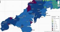
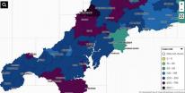
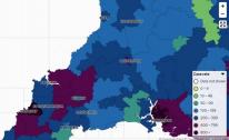
The new daily figures show the case rates in areas across the Duchy
Covid-19 continues to soar in Newquay with infection rates still double the national average, the latest figures show.
New figures, which cover the week to July 28, show that Newquay East was still the area with the highest infection rate in the county at 702.4 per 100,000.
This is nearly double England's national average of 296.6 per 100,000, according to the governments website.
However, despite the infection rate remaining high, it was down from 722.5 the day before.
Additionally, Newquay West's data was also above the national average at 540.3 per 100,000, up from 499.8.
Other areas which have seen an increase in the infection rate from the day before include Bude & Stratton, Launceston, and Perranporth & Goonhavern.
Below we take a look at the latest data with the figure on the left showing the new positives from July 22 to 28 and the figure on the right is the rate of cases per 100,000.
| 1440 | Cornwall | Altarnun & Stoke Climsland | 13 | 153 |
| 1441 | Cornwall | Bodmin East | 32 | 379.1 |
| 1442 | Cornwall | Bodmin West | 13 | 162.5 |
| 1443 | Cornwall | Bude & Stratton | 32 | 300 |
| 1444 | Cornwall | Callington & Pensilva | 15 | 179.7 |
| 1445 | Cornwall | Camborne East | 22 | 256.7 |
| 1446 | Cornwall | Camborne South | 12 | 163.3 |
| 1447 | Cornwall | Camborne West | 12 | 172.2 |
| 1448 | Cornwall | Camelford & Tresmeer | 10 | 137.9 |
| 1449 | Cornwall | Crackington & Tintagel | 14 | 194.7 |
| 1450 | Cornwall | Crowan, Wendron & Stithians | 25 | 295.5 |
| 1451 | Cornwall | Dobwalls, Addington & Menheniot | 22 | 248.6 |
| 1452 | Cornwall | Falmouth East | 27 | 385.7 |
| 1453 | Cornwall | Falmouth North | 28 | 356.6 |
| 1454 | Cornwall | Falmouth West & South | 25 | 305.1 |
| 1455 | Cornwall | Grampound Road, St Newlyn East and Cubert | 27 | 393.2 |
| 1456 | Cornwall | Gunnislake & Calstock | 15 | 232.3 |
| 1457 | Cornwall | Hayle | 20 | 197.2 |
| 1458 | Cornwall | Helston | 29 | 238.5 |
| 1459 | Cornwall | Illogan & Portreath | 9 | 126.4 |
| 1460 | Cornwall | Kingsand, Antony & Maryfield | 25 | 395.3 |
| 1461 | Cornwall | Lanreath, Pelynt & Polraun | 13 | 165.5 |
| 1462 | Cornwall | Launceston | 19 | 174 |
| 1463 | Cornwall | Liskeard | 15 | 256.2 |
| 1464 | Cornwall | Looe & Polperro | 11 | 220.2 |
| 1465 | Cornwall | Lostwithiel & Penwithick | 18 | 163.4 |
| 1466 | Cornwall | Marazion, St Erth & Gwinear Gwithian | 22 | 228.6 |
| 1467 | Cornwall | Mevagissey & Polgooth | 15 | 186.8 |
| 1468 | Cornwall | Mid Saltash | 11 | 200.8 |
| 1469 | Cornwall | Mylor Bridge & Frogpool | 7 | 113.4 |
| 1470 | Cornwall | Newquay East | 70 | 702.4 |
| 1471 | Cornwall | Newquay West | 40 | 540.3 |
| 1472 | Cornwall | Padstow & St Issey | 21 | 295.1 |
| 1473 | Cornwall | Par | 13 | 182.8 |
| 1474 | Cornwall | Penryn | 27 | 323.8 |
| 1475 | Cornwall | Penzance North | 22 | 265.6 |
| 1476 | Cornwall | Penzance Quay | 13 | 195.5 |
| 1477 | Cornwall | Penzance South & Newlyn | 12 | 202.4 |
| 1478 | Cornwall | Perranporth & Goonhavern | 20 | 336.9 |
| 1479 | Cornwall | Ponsanooth, Mabe Burnthouse & Constantine | 30 | 261 |
| 1480 | Cornwall | Pool & Illogan Highway | 15 | 173 |
| 1481 | Cornwall | Porthleven, Breage & Praa Sands | 24 | 346.3 |
| 1482 | Cornwall | Poundstock & Kilkhampton | 14 | 185.2 |
| 1483 | Cornwall | Probus & Roseland | 19 | 237.2 |
| 1484 | Cornwall | Redruth North | 7 | 94.3 |
| 1485 | Cornwall | Redruth South | 11 | 136.1 |
| 1486 | Cornwall | Roche & Goss Moor | 17 | 215.4 |
| 1487 | Cornwall | Saltash Latchbrook & St Stephens | 6 | 107.6 |
| 1488 | Cornwall | Saltash Town & Pillmere | 28 | 394.1 |
| 1489 | Cornwall | Shortlanesend, Chacewater & Carnon Downs | 22 | 243.4 |
| 1490 | Cornwall | St Agnes & Mount Hawke | 24 | 286.7 |
| 1491 | Cornwall | St Austell Central | 10 | 98.5 |
| 1492 | Cornwall | St Austell East & Carlyon Bay | 21 | 212.9 |
| 1493 | Cornwall | St Austell North & Carclaze | 11 | 150.4 |
| 1494 | Cornwall | St Breward, Tredethy & Lanivet | 9 | 144.2 |
| 1495 | Cornwall | St Columb Major & St Mawgan | 28 | 244.9 |
| 1496 | Cornwall | St Columb Minor & Porth | 45 | 512.2 |
| 1497 | Cornwall | St Day & Lanner | 19 | 311.7 |
| 1498 | Cornwall | St Germans & St Mellion | 16 | 237.9 |
| 1499 | Cornwall | St Ives & Halsetown | 27 | 388.2 |
| 1500 | Cornwall | St Just & Land's End | 13 | 232 |
| 1501 | Cornwall | St Neot & St Cleer | 8 | 121.1 |
| 1502 | Cornwall | The Lizard | 11 | 114.2 |
| 1503 | Cornwall | Torpoint | 19 | 364.4 |
| 1504 | Cornwall | Towednack, Lelant & Carbis Bay | 17 | 278.5 |
| 1505 | Cornwall | Trebetherick & Whitecross | 13 | 230.9 |
| 1506 | Cornwall | Trewoon, Coombe & Foxhole | 30 | 356.5 |
| 1507 | Cornwall | Truro East | 21 | 246.7 |
| 1508 | Cornwall | Truro South & Central | 21 | 325.1 |
| 1509 | Cornwall | Truro West | 25 | 238.3 |
| 1510 | Cornwall | Tywardreath & Fowey | 17 | 280.7 |
| 1511 | Cornwall | Wadebridge | 14 | 197.2 |
| 1512 | Cornwall | West Penwith & St Buryan | 11 | 165.5 |
- Printer-friendly version
- Login or register to post comments
- Permalink
Contributions
- Angarrack Defibrillator Team (25)
- Angarrack Inn (336)
- Angarrack Methodist Chapel (3)
- Carol (15)
- Gail (1)
- GordonG (12)
- Hayle Development Group on Facebook (5)
- Hayle Harbour Authority (4)
- Hayle Town Council (5)
- louise (1)
- Lynne (94)
- Mal (1)
- MattBuckley66 (9)
- Neil (22)
- Neils Garden Care (9)
- Russell (21)
- Secretary - Christmas Lights (122)
- Steve (3)
- webmaster (5033)
Book page
Similar
- 210721 | Covid cases in Cornwall rise nearly a thousand in week: cluster map B
- 210717 | No part of Cornwall now Covid cluster free amid large spikes in some areas
- 210715 | Covid in Cornwall: Thursday, July 15 - a big jump in cases
- 210715 | As Covid cases continue to rise just one area of Cornwall remains off the cluster map
- 210716 | The government still “expect” and “recommend” people to wear a face covering in crowded and enclosed spaces
Similar across site
- 210802 | Covid-19 continues to soar in Newquay with infection rates still double the national average, the latest figures show
- 210721 | Covid cases in Cornwall rise nearly a thousand in week: cluster map B
- 210717 | No part of Cornwall now Covid cluster free amid large spikes in some areas
- 210715 | Covid in Cornwall: Thursday, July 15 - a big jump in cases
- 210715 | As Covid cases continue to rise just one area of Cornwall remains off the cluster map


Recent comments
14 weeks 2 days ago
49 weeks 6 days ago
51 weeks 4 days ago
51 weeks 4 days ago
1 year 9 weeks ago
1 year 21 weeks ago
1 year 46 weeks ago
2 years 4 weeks ago
2 years 16 weeks ago
3 years 41 weeks ago