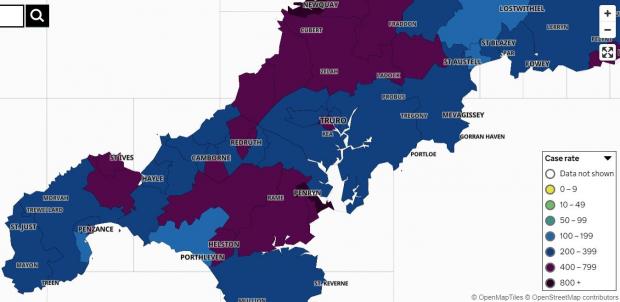
Most parts of Cornwall have seen a rise in Covid cases over the past week - and in some places they're substantial.
As a whole, Cornwall and Isles of Scilly recorded 2,160 new cases over the seven days leading up to Monday this week, August 9.
This was 681 more than recording during the preceding week, marking a 46% rise.
Cases from the most recent five days are not shown due to incomplete data.
The case rate is now averaging 375.3 cases per 100,000 people - much higher than the 257.2 cases per 100,000 people last Saturday.
Falmouth remains the current Covid hotspot in Cornwall with the highest number of cases, after recording 189 across its three clusters: Falmouth West & South (55, up 29), Falmouth East (71, up 39) and Falmouth North (63, up 18). This is 86 additional cases to the preceding week.
Neighbouring Penryn has also seen a particularly sharp increase, going from 29 weekly cases to 91.
The second highest figures are being recorded in Newquay, where 143 new cases were recorded across the seven-day period, compared to 98 during the previous week.

Further south, the Lizard Peninsula - referred to as The Lizard on the map, but also including Mullion, St Keverne and the Meneage parishes - has risen from single figures last week (9) to 26 new cases now.
Helston has also risen, from 24 to 55, but the nearby Porthleven, Breage & Praa Sands cluster is one of the few places to have seen a fall, down two with 13 recorded.
In West Cornwall, Towednack, Lelant & Carbis Bay has gone from 11 cases to 29, and St Ives & Halsetown also from 11 cases, to 35.
St Agnes & Mount Hawke has doubled in a week, from 25 to 50.
Further east has also seen rises, but on a smaller scale.

The map shows positive cases by 'Middle Super Output Area' - the name the government gives to the break-up of larger towns and groups of neighbouring towns and villages, with groupings covering a greater area than others.
The minimum population in each area is 5,000 and the average is 7,200.
Clusters are only shown when there are three or more new cases reported at any one time.
Anywhere with between zero and two cases shows white in order to "protect the privacy of individuals and prevent disclosure", the accompanying information states.
The full list of clusters now on the map is:
St Just & Land's End (12, down three)
West Penwith & St Buryan (15, up two)
Penzance South & Newlyn (7, down seven)
Penzance North (25, up seven)
Penzance Quay (28, up 13)
Towednack, Lelant & Carbis Bay (29, up 18)
St Ives & Halsetown (35, up 24)
Hayle (29, up six)
Marazion, St Erth & Gwinear Gwithian (31, up 11)
Porthleven, Breage & Praa Sands (13, down two)
Helston (55, up 31)
The Lizard (26, up 17)
Crowan, Wendron & Stithians (36, up 16)
Ponsanooth, Mabe Burnthouse & Constantine (53, up 27)
Falmouth West & South (55, up 29)
Falmouth East (71, up 39)
Falmouth North (63, up 18)
Penryn (91, up 62)
Mylor Bridge & Frogpool (14, up two)
Camborne West (27, up 12)
Camborne South (31, up ten)
Camborne East (26, no change)
Pool & Illogan Highway (34, up 13)
St Day & Lanner (14, up three)
Redruth South (44, up 32)
Redruth North (30, up 21)
Illogan & Portreath (25, up 17)
St Agnes & Mount Hawke (50, up 25)
Shortlanesend, Chacewater & Carnon Downs (21, up one)
Truro West (33, up 13)
Truro South & Central (30, up nine)
Truro East (24, up seven)
Probus & Roseland (20, no change)
Mevagissey & Polgooth (19, down four)
Perranporth & Goonhavern (41, up 12)
Grampound Road, St Newlyn East and Cubert (40, up 17)
Newquay West (40, up 17)
Newquay East (103, up 28)
St Columb Minor & Porth (56, up nine)
St Columb Major & St Mawgan (46, up 15)
Trewoon, Coombe & Foxhole (36, down one)
St Austell North & Carclaze (22, up five)
St Austell Central (27, up six)
St Austell East & Carlyon Bay (17, down one)
Par (23, up ten)
Tywardreath & Fowey (23, up ten)
Lanreath, Pelynt & Polraun (16, down four)
Looe & Polperro (32, up 27)
St Germans & St Mellion (7, down eight)
Kingsand, Antony & Maryfield (24, up four)
Torpoint (15, down five)
Saltash Town & Pillmere (20, up one)
Mid Saltash (25, up 11)
Saltash Latchbrook & St Stephens (14, up three)
Dobwalls, Addington & Menheniot (22, down one)
Liskeard (6, down 14)
Lostwithiel & Penwithick (17, down three)
Roche & Goss Moor (22, down eight)
Padstow & St Issey (24, up ten)
Trebetherick & Whitecross (15, seven)
Wadebridge (25, up 11)
St Breward, Tredethy & Lanivet (18, up nine)
Bodmin West (25, up four)
Bodmin East (35, up ten)
Dobwalls, Addington & Menheniot (22, down one)
Liskeard (6, down 14)
Callington & Pensilva (15, down six)
Gunnislake & Calstock (16, up two)
St Neot & St Cleer (22, up nine)
Trebetherick & Whitecross (15, up seven)
Crackington & Tintagel (17, up two)
Camelford & Tresmeer (21, up nine)
Altarnun & Stoke Climsland (18, up 11)
Launceston (27, up nine)
Camelford & Tresmeer (21, up nine)
Crackington & Tintagel (17, up two)
Poundstock & Kilkhampton (15, no change)
Bude & Stratton (27, down nine)


Recent comments
14 weeks 2 days ago
49 weeks 6 days ago
51 weeks 4 days ago
51 weeks 4 days ago
1 year 9 weeks ago
1 year 21 weeks ago
1 year 46 weeks ago
2 years 4 weeks ago
2 years 16 weeks ago
3 years 41 weeks ago