
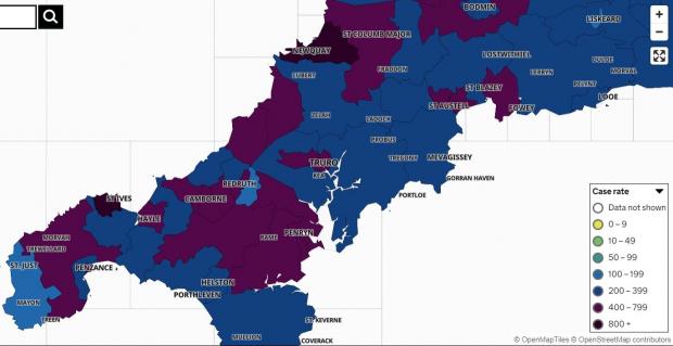
Cornwall has gone purple again after the case rate rose further, putting it into a new category.
The case rate is now averaging 434.2 cases per 100,000 people, putting it over the 400,000 case threshold and moving it up from dark blue on the government's map, into purple - the second highest from the top.
It compares to a rate of 375.3 cases per 100,000 people last Saturday. The figure is calculated by diving the seven-day case total by the area population, then multiplying by 100,000. In this the government has used the mid-2020 estimates for the permanent population of Cornwall and the Isles of Scilly.
It's after Cornwall and Isles of Scilly recorded 2,499 new cases during the seven days leading up Monday this week, August 16. There is a five-day delay due to the most recent data being incomplete.
This amount was 335 more cases than the number recorded during the preceding seven days, marking a rise of 15.5%.
READ NEXT:
In the midweek update Newquay moved into the top spot for the town with highest number of cases in Cornwall, and it remains there today, with the numbers growing further.
It recorded 205 new cases during those seven days, up from 178 a week earlier. The latest figures for its two clusters are: Newquay West 79 (up five) and Newquay East 126 (up 22).

This week Cornwall Council said any impact of the Boardmasters festival in Newquay on case figures would not yet show, due to the delay in symptoms and subsequent recording of results.
It added that Covid cases in Newquay were already high before the festival - but that it was "expecting the event to have contributed to the increase in case numbers" in the coming days.
Another town that previously saw high figures, Falmouth, has started to see a fall overall. The town recorded a combined 160 cases, which was 29 fewer than during the previous seven days. The figures now are Falmouth West & South 58 (up three), Falmouth East 50 (down 21) and Falmouth North 52 (down 11).
Penryn also saw a large fall in cases, down from a weekly total of 92 to only 38 in the most recent figures.
St Ives's cases continue to grow though, rising from 35 to 56, while nearby Hayle has gone from 29 to 63.
Further east, Saltash Town & Pillmere's cases have doubled in a week, from 20 to 40.
A number of other areas, however, have seen falls.
The map shows positive cases by 'Middle Super Output Area' - the name the government gives to the break-up of larger towns and groups of neighbouring towns and villages, with groupings covering a greater area than others.
The minimum population in each area is 5,000 and the average is 7,200.
Clusters are only shown when there are three or more new cases reported at any one time.
Anywhere with between zero and two cases shows white in order to "protect the privacy of individuals and prevent disclosure", the accompanying information states.
The full list of clusters now on the map is:
St Just & Land's End (8, down four)
West Penwith & St Buryan (33, up 18)
Penzance South & Newlyn (16, up nine)
Penzance Quay (29, up one)
Penzance North (27, up two)
Towednack, Lelant & Carbis Bay (20, down nine)
St Ives & Halsetown (56, up 21)
Hayle (63, up 34)
Marazion, St Erth & Gwinear Gwithian (36, up five)
Porthleven, Breage & Praa Sands (18, up five)
Helston (48, down six)
The Lizard (27, up one)
Crowan, Wendron & Stithians (34, down two)
Ponsanooth, Mabe Burnthouse & Constantine (47, down seven)
Falmouth West & South (58, up three)
Falmouth East (50, down 21)
Falmouth North (52, down 11)
Penryn (38, down 54)
Mylor Bridge & Frogpool (52, down 11)
Camborne West (33, up seven)
Camborne South (31, no change)
Pool & Illogan Highway (51, up 17)
Redruth South (39, down six)
Redruth North (26, down four)
St Day & Lanner (12, down two)
Illogan & Portreath (24, down one)
St Agnes & Mount Hawke (45, down five)
Shortlanesend, Chacewater & Carnon Downs (32, up 11)
Truro West (54, up 21)
Truro South & Central (46, up 16)
Truro East (43, up 18)
Probus & Roseland (32, up 13)
Mevagissey & Polgooth (27, up eight)
Perranporth & Goonhavern (32, down nine)
Grampound Road, St Newlyn East and Cubert (26, down 14)
Newquay West (79, up five)
Newquay East (126, up 22)
St Columb Minor & Porth (76, up 20)
St Columb Major & St Mawgan (48, up two)
Trewoon, Coombe & Foxhole (20, down 17)
St Austell North & Carclaze (37, up 15)
St Austell Central (41, up 14)
St Austell East & Carlyon Bay (57, up 40)
Par (25, up two)
Tywardreath & Fowey (31, up 14)
Lanreath, Pelynt & Polraun (18, up one)
Looe & Polperro (10, down 22)
St Germans & St Mellion (21, up 14)
Kingsand, Antony & Maryfield (23, down one)
Torpoint (18, up three)
Saltash Town & Pillmere (40, up 20)
Mid Saltash (24, down one)
Saltash Latchbrook & St Stephens (20, up six)
Dobwalls, Addington & Menheniot (25, up three)
Liskeard (9, up three)
Lostwithiel & Penwithick (28, up 11)
Roche & Goss Moor (25, up three)
Padstow & St Issey (22, down two)
Trebetherick & Whitecross (23, up seven)
Wadebridge (28, up three)
St Breward, Tredethy & Lanivet (26, up nine)
Bodmin West (16, down nine)
Bodmin East (27, down eight)
St Neot & St Cleer (17, down five)
Callington & Pensilva (22, up seven)
Gunnislake & Calstock (10, down six)
Altarnun & Stoke Climsland (25, up seven)
Launceston (47, up 20)
Crackington & Tintagel (29, up 12)
Camelford & Tresmeer (36, up 15)
Poundstock & Kilkhampton (28, up 13)
Bude & Stratton (40, up 13)


Recent comments
14 weeks 2 days ago
49 weeks 6 days ago
51 weeks 4 days ago
51 weeks 4 days ago
1 year 9 weeks ago
1 year 21 weeks ago
1 year 46 weeks ago
2 years 4 weeks ago
2 years 16 weeks ago
3 years 41 weeks ago