140120 | Transport Assessment| PA14/00532 | Hayle Shopping Park And Marsh Lane Nature Reserve Marsh Lane
Extracts from ASSESSMENT - TRANSPORT - Part 1 Of 10 http://planning.cornwall.gov.uk:8181/rpp/showimage.asp?j=PA14/00532&inde...
1.2 This is a retail led proposal for 14,589 m2 gross floor area (GFA) of A1 (non‐food) land use
with 951 m2 of ancillary A3 (restaurants). Its anchor and driver is a Debenhams store of
5,796 m2 GFA.
...
1.10 A new footway will lead from the site along Grist Lane to Angarrack to provide easy and safe
access from the village to the facilities at Marsh Lane. Grist Lane itself will remain of a rural
nature retaining the character distinction between the Marsh Lane area and the village.
Local Highway Network
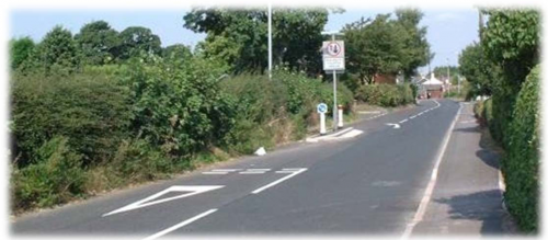
2.6 Grist Lane is a narrow rural highway with no road markings and no footway connecting
Angarrack with the WCSP. There is vegetation on both sides of the highway and street
lighting is present. Grist Lane is illustrated below.
...
2.13 ‘Count on Us’ were commissioned to undertake traffic surveys on Wednesday 23rd October
and Saturday 16th November 2013 at the following junctions:
Loggans Moor roundabout;
Marsh Lane / West Cornwall Shopping Park roundabout;
Marsh Lane Industrial Estate junction;
Carwin Rise / Premier Inn mini‐roundabout;
Carwin Rise / Guildford Road double mini‐roundabout;
St Erth gyratory;
B3301 / The Causeway junction; and
B3301 / Nut Lane mini‐roundabout.
...
2.17 Accidents are recorded as either ‘slight’, ‘serious’ or ‘fatal’. Analysis of the data
demonstrated that during the survey period and within the study area there were:
50 recorded accidents causing 65 casualties, of which 23 were vulnerable road users;
44 accidents were recorded as slight, 4 as serious and 2 fatal;
39 accident occurred during dark or periods requiring street lighting;
19 accidents occurred during wet/damp conditions;
20 ‘damage only’ accidents were also recorded during the survey period.
...
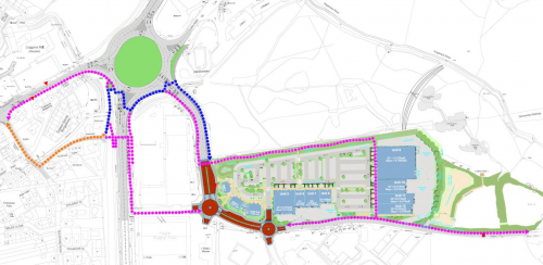
4.5 Critically, Cranford’s ownership of the land east of Marsh Lane, allows Marsh Lane to be
widened to provide not just an appropriate vehicular link from Loggans Moor but a high
quality and attractive pedestrian and cycle route linking the rest of Hayle with the site and
the nature reserve. Furthermore, the improved pedestrian linkages will include an at‐grade
crossing of the A30 which will significantly enhance the walk to the town centre and remove
the need to use the existing footbridge. This is particularly beneficial for wheelchair users,
cyclists and parents with prams as it provides a step‐free environment. This is shown in more
detail in Appendix H.
...
4.19 The customer car park provision will be 514 spaces.
4.20 Staff parking provision will be located in a dedicated and managed staff parking area behind
the eastern service yard. This area will allow parking for up to 70 staff only vehicles. This
area will be controlled by a lift‐arm barrier and relevant staff will be provided with swipe
cards (or similar). An additional 12 staff‐parking spaces are provided in the Debenhams area
of the eastern service yard. Therefore the total staff‐parking provision is 82 spaces. The car
parking areas are shown in Appendix G.
4.21 A car parking accumulation assessment (which includes staff parking) has been undertaken
and is presented in Appendix I. The proposed parking provision is sufficient to accommodate
the anticipated demand. It shows peak parking demand at between 423 and 516 depending
on the proxy used for the assessment and this is well within the total capacity of 596 spaces.
Therefore there is sufficient parking to accommodate typical peak demand.
4.22 Within the customer car park 29 spaces will be allocated for disabled users (6%) and 24 will
be allocated for Parent & Child users (5%). These spaces are spread across the car park
adjacent to the store entrances.
4.23 Within the car park there will six dedicated pick up spaces for Debenhams, to be located in
the north‐eastern corner and adjacent to the store entrance.
...
4.38 A footway will also be provided from the southern boundary of the site along Grist Lane
towards Angarrack, improving the pedestrian connectivity from Angarrack not only to the
development, but to the WCSP and Hayle also. The existing highway width along this section
of Grist Lane will not be widened or narrowed beyond its current layout. The footway will be
provided to the north of the existing edge of carriageway between the site and the edge of
land controlled by Cranford, which is at the north‐western edge of the village.
...
Angarrack Traffic Calming
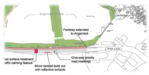
4.50 Following feedback from the residents of Angarrack during the scheme consultation, a new
rural gateway feature will be provided on Grist Lane, just prior to entering the village. An
example of rural gateways is illustrated below.
4.51 The plan below illustrates the possible location and detail of the proposed Angarrack
gateway feature.
...
Contributions
- Angarrack Defibrillator Team (25)
- Angarrack Inn (336)
- Angarrack Methodist Chapel (3)
- Carol (15)
- Gail (1)
- GordonG (12)
- Hayle Development Group on Facebook (5)
- Hayle Harbour Authority (4)
- Hayle Town Council (5)
- louise (1)
- Lynne (94)
- Mal (1)
- MattBuckley66 (9)
- Neil (22)
- Neils Garden Care (9)
- Russell (21)
- Secretary - Christmas Lights (122)
- Steve (3)
- webmaster (5033)
Book page
Similar
- 140120 | Flood Relief | PA14/00532 | Hayle Shopping Park And Marsh Lane Nature Reserve Marsh Lane
- 140311 | Residents say Hayle retail park plans pose no flood risk | The Cornishman
- 140120 | Community Engagement | PA14/00532 | Hayle Shopping Park And Marsh Lane Nature Reserve Marsh Lane
- 140120 | PA14/00532 | Hayle Shopping Park And Marsh Lane Nature Reserve Marsh Lane
- 131121 | 395 TO RECEIVE A PRESENTATION FROM BILL OAKLEY FROM CRANFORD DEVELOPMENTS AND ASSOCIATED CONSULTANTS R
Similar across site
- 140120 | Transport Assessment| PA14/00532 | Hayle Shopping Park And Marsh Lane Nature Reserve Marsh Lane
- 140120 | Flood Relief | PA14/00532 | Hayle Shopping Park And Marsh Lane Nature Reserve Marsh Lane
- 140311 | Residents say Hayle retail park plans pose no flood risk | The Cornishman
- 140120 | Community Engagement | PA14/00532 | Hayle Shopping Park And Marsh Lane Nature Reserve Marsh Lane
- 140120 | PA14/00532 | Hayle Shopping Park And Marsh Lane Nature Reserve Marsh Lane
Hayle and Angarrack news | Google
- Hayle Runners enjoy outing at Turkey Trot - The Voice
- Hayle Runners enjoy outing at Turkey Trot - The Voice
- People rescued from burning Cornwall house as fire engulfs bedroom - Cornwall Live
- People rescued from burning Cornwall house as fire engulfs bedroom - Cornwall Live
- People rescued from burning Cornwall house as fire engulfs bedroom - Cornwall Live
- People rescued from burning Cornwall house as fire engulfs bedroom - Cornwall Live
- People rescued from burning Cornwall house as fire engulfs bedroom - Cornwall Live
- People rescued from burning Cornwall house as fire engulfs bedroom - Cornwall Live
- People rescued from burning Cornwall house as fire engulfs bedroom - Cornwall Live
- People rescued from burning Cornwall house as fire engulfs bedroom - Cornwall Live
- People rescued from burning Cornwall house as fire engulfs bedroom - Cornwall Live
- People rescued from burning Cornwall house as fire engulfs bedroom - Cornwall Live
Problems within 7km of Hayle | FixMyStreet
Hayle News
- Photos from Hayle Town Council's post
- For those of you struggling with pain we have our next pain cafe on Tuesday 3oth July from 1-3pm in the annex next door
- For those of you struggling with pain we have our next pain cafe on Tuesday 3oth July from 1-3pm in the annex next door
- A post from Hayle Town Council
- The Mobile Library van is in Hayle tomorrow from 11am-1pm
- We recently had the pleasure of welcoming a student for work experience at Hayle Town Council
- Photos from Hayle Town Council's post
- A post from Hayle Town Council
Facebook - Hayle Town Council
- Photos from Hayle Town Council's post
- For those of you struggling with pain we have our next pain cafe on Tuesday 3oth July from 1-3pm in the annex next door
- For those of you struggling with pain we have our next pain cafe on Tuesday 3oth July from 1-3pm in the annex next door
- A post from Hayle Town Council
- The Mobile Library van is in Hayle tomorrow from 11am-1pm
Facebook - Hayle and St Ives Police
- DO YOU KNOW WHO DID THIS?? Someone has sprayed this terrible graffiti on the wa...
- KEEP YOUR SHED AND GARAGE SAFE!!!! Although here in West Cornwall we live in a r...
- We have been asked to share this post. It serves as a horrific warning about the...
- http://m.westbriton.co.uk/Thieving-neighbour-lives-hell/story-26538405-detail/st...
- Serious RTC A30 Chiverton Cross. Witnesses sought after A30 collision, near T...
- Missing man Andrew Lambert found safe Found in Oxfordshire A man who went miss...


Calming? Unable to leave village more like!
Does this strike anyone else as far too near - the village begins at the current Angarrack sign not hard by the Chapel and the wrong way round?! it prioritises people pushing into the village so cars will be trapped outside the chapel unable to leave? but then as they've not given us any priority over traffic at the Marsh lane roundabout leaving the development I guess we weren't going to get far anyway!!